Something about Llamas. I'm not sure what it is. So here's an entry for them. Iwas stoked that there is Llamas at MP and spent most of our guided tour taking photos of them.


 I figure they own the place.
I figure they own the place.
I figure they own the place.


The cloud. The morning with an empty MP.


 Something about 3's in the Incan culture.
 There is a nearby mountain that you can climb called Huayna Pichu. It's a pretty steep climb so it stops some of the tourists. But the views are great.
 Bella on some floating stairs showing the steepness of the site.
 Woops. You get the idea. Huayna Pichu behind the site.
 Then there are the crowds. By 10.30am the place is crowded with treks coming in from all directions plus the day-trippers from Cusco. All crowded around a rock. It's apparently a sun dial/calendar.

 Us in amongst it.
 A group of 4 tourists, one guide, a cook, two horsemen and 3 horses. The day starts pretty easy with 11km of flat ground. But then the descent started. 8kms in 2 hours of some steep downhill to our campsite.
  Knees hurting and toes pushing through the end of our shoes we eventually make it to our spectacular campsite. The saddle in the middle top is where we would be heading to the next day, little to our knowledge.
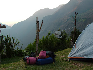

Some cool, big asparragas (??) looking vegetation along the way (during the flat bit).
The second day was the painful day. By 5.30am we were walking, a quick half hour downhill and then the ascent. 4.5 hours up. About 7km of zig-zagging trails up some of the steepest slopes I've seen. I think we climbed 1500m vertically.
The green patch was our campsite the previous night. We had climbed down to the river and back up again by about 7am.  Some exhausted faces after the ascent, but now with the ruins on pretty much the same level (between our heads). We had about 2.5hrs rest along with some lunch and then headed off for the final 4kms to Choquequirao. Below shows us getting closer, with the big agricultural terraces below the city.
Finally we made it by about 2pm. Walking along the terraces, while approaching the city.
An overall impression.
 Close ups.
 Local archaelologists playing football on the sacred site.
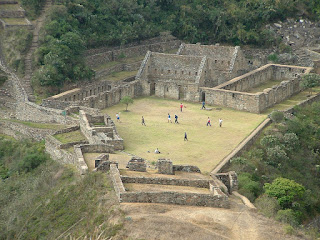
The Incans were not great record keepers to so not a lot is known about this site or many others. It was thought to be built about 1200 and lasted through to the 1400-1500's. It was an administrative city as oppossed to the possibly religous Machu Pichu. It is thought to be much larger than MP but has not been excavated or restored to the same extent. Mainly due to its remote location. The best part was there were only 2 other tourists up there all afternoon. We pretty much had the place to ourselves. This is in complete contrast to Machu Pichu as you will see later.
 Our group.
 Stairs to the unknown. Probably more terracing.
We headed up again the next morning. Another 5am start. This time the ruins were covered in cloud and rain and had a whole new feel.  We headed down the other side of the city to some terraces that had stone Llamas incorporated in the wall. This is a great example of the Incans foresight in their construction to include such features. Probably some offering to Pacha Mama (Mother Earth).
We then headed home along the same trail. It was 4 days in total with over 64kms covered. A hard trail but well worth it.


Making merchandise. The ground is spongey as you would expect.
Very colourful girls singing us a goodbye song.
Reed boats that move and steer quite well considering the're made of reeds and powered by two guys with oars. Apparently a puma's head on the front of the boat on the right.


We did get to dress up in local clothing for a local 'discoteque'. But the next morning we were off to our third island. Kind of the same but different to Amantani. Agriculture is still pretty traditional, including the uniform.

 Copa, copacabana. The coldest place south of Havana. Looks nice though.....
A nice sunset over the lake.
Isla del Sol in the foreground with Copacabana being in the top right. Very hilly island. All the lines on the right hand side of the hill are stone walled terracing for agriculture. It is everywhere on the island and must have taken a huge amount of manual labour to build.
Essentially we did about 6 hours of walking on Isla del Sol. This may sound not too bad. But consider it being cold, any slight incline completely exhausted you thanks to the altitude and a complete lack of signs or directions (which means you do extra walking cause you get lost). So although it was a tiring day, it was well worth it. Lake Titicaca is very beautiful once the sun comes out and it did restore my lack of being near water after being landlocked for over 3 months.
Beautiful vegetation on the 3 hour walk up the island. The whole point of the walk, which we were questioning at some stages, was to see some Incan ruins and the birthplace of Manco Capac. Luckily we eventually made it.

 This was our first Incan ruins so we were impressed. Although i am sure we will get overdosed in the next month in Peru. The table below is where sacrifices were made, anything from llamas and alpacas to any unfortunate young ladies who were considered beautiful enough.
 And yes, below is a puma's head with some kind of triangle thing on the right that symbolises something. A little was lost in the Spanish translation we interpreted but this rock is very sacred and is apparently were Manco Capac rose from. Very impressive.
 A nice sandy but very cold beach.
